The tool offers information from public databases and Opi surveys on the vulnerabilities that affect the lives and territories of groups in isolation in the Brazilian Amazon.

On 15th August, Bruno Pereira would have turned 42 if he hadn't been brutally murdered in the Javari Valley in June 2022. As a tribute to him and honouring the work to which he dedicated his life, the Observatory of Isolated and Recently Contacted Indigenous Peoples (Opi), the organisation Bruno founded in 2020, is launching a platform for monitoring isolated peoples in the Brazilian Amazon today. The tool gathers information from public databases and field surveys by the Observatory's networks. Combined, this information makes it possible to analyse the living conditions and territories of these groups. The initiative is a collaboration between Opi and the Coordination of Indigenous Organisations of the Brazilian Amazon (Coiab) and Operação Amazônia Nativa (Opan) - a nonprofit focused on indigenous rights. Bruno Pereira was one of the platform's creators and had been part of the technical team from the beginning.
Learn more about the Mopi platform
The platform was baptised Mopi, a word that in the Zo'é language can be translated as "to sting". Derived from the term opi - the same language expression for sting and the Wayana word for plant medicine - Mopi is also the nickname of the platform for Monitoring Isolated Indigenous Peoples, which presents the public with a comprehensive set of data on the threats and pressures facing groups living in isolation in the country. Like the Opi - medicine for relatives and poison for enemies - the Mopi was born for the dual purpose of stinging and healing.
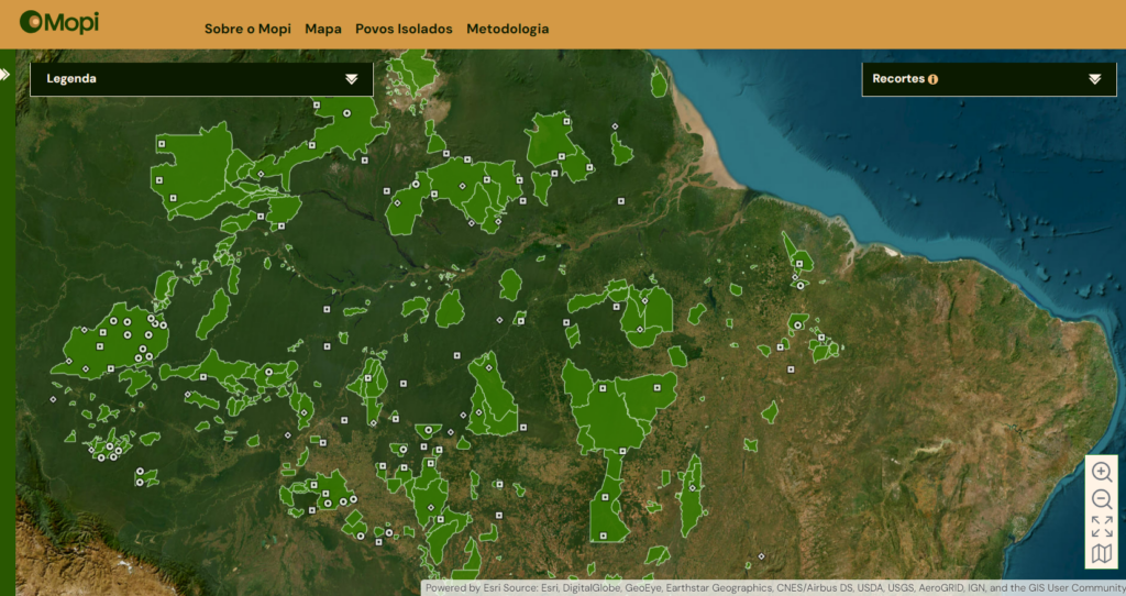
Mopi is a geospatial platform focusing primarily on the 114 records of isolated peoples recognised by the Brazilian state through the National Foundation for Indigenous Peoples (FUNAI) - plus one record, which was confirmed in 2021 but not recognised by the anti-indigenous administration of Bolsonaro's government, of a group in isolation living in the Mamoriá region, in the southern part of Amazonas state. Designed to monitor the situation of vulnerability experienced by isolated indigenous peoples, the tool maps 115 records which can visualised on an interactive map. The locations of the records appear with different coordinates deliberately in order to avoid the exact identification of the territories of these peoples, due to the risk of attacks against them.
Navigate Mopi's interactive map
By compiling this information, Mopi can contribute to the dissemination of data on the situation of vulnerability experienced by these peoples, providing support for the work of indigenous organisations, indigenists and public agencies who work to the rights and protect the lives of the Isolated. The data was carefully selected by the platform's technical team, formed by indigenous researchers specialising in areas of knowledge such as indigenous ethnology, human rights, geoprocessing, health, ecology and information technology.
The construction of a monitoring methodology is the main aim of the technical team, which has dedicated itself to defining guidelines for the collection, processing and systematisation of information about the situation of vulnerability faced by isolated peoples. This methodology, which is constantly being improved, seeks to ensure the reliability of the data collected and enable comparisons between monitored areas.
Socio-environmental vulnerability
The assessment of the situation experienced by isolated indigenous peoples is based on the theoretical-methodological framework of vulnerability proposed by the United Nations Intergovernmental Panel on Climate Change (IPCC). Adapted for analysing the environmental vulnerability of Indigenous Lands in the Legal Amazon by researcher Ana Rorato, from the National Institute for Space Research (INPE), the framework presents guidelines for studying socio-environmental systems susceptible to the impacts of climate change.
Under the methodology, the concept of vulnerability is conceived as "the degree to which a [human, environmental or human-environmental] system is susceptible to, or unable to cope with, the adverse effects of change". Thus, a system is expected to be more vulnerable if it is exposed to threats, if it is sensitive to them, and if it has a low response capacity to deal with them and their impacts. The approach was adapted by the technical core of the Mopi Platform to analyse different indicators to demonstrate the exposure, sensitivity and resilience of isolated peoples' records.
Indicators
Data on threats and pressures are mapped and organised by the Mopi team with attention to various dimensions, each associated with a set of thematic information that describes the multiple factors and processes that influence the situation of vulnerability of isolated peoples.
Learn about the dimensions that can be observed in Mopi:
Territory
The territory dimension considers data relating to the territorial situation of the isolated indigenous people. In this dimension, we compile data on the stage of the regularisation process of the Indigenous Land, as well as on the presence of Conservation Units, Settlement Projects, Quilombola Territories, Certified Rural Properties and Rural Environmental Registries overlapping its area of occupation and its surrounding area. The data gathered in this dimension is secondary, provided by public bodies.
Development Projects
The development project's dimension includes data on the presence of hydroelectric dams, transmission lines, railways, highways, pipelines and mining operations in the areas of occupation and around the records of isolated indigenous peoples. The data compiled in this dimension is secondary, provided by public agencies.
Environment
In the environmental dimension, we compiled data on deforestation, forest degradation and integrity, fire scars and hotspots in the area of occupation and in the area surrounding the records. Data on illegal mining was also included in this dimension. The data that makes up the indicators for deforestation, forest degradation, hotspots and forest integrity is made available periodically by the National Institute for Space Research (INPE). The data relating to burnt areas, meanwhile, is a product of the Moderate Resolution Imaging Spectroradiometer (MODIS) sensor, while the data relating to illegal mining was obtained from the Amazon Georeferenced Socio-Environmental Information Network (RAISG) website.
Invasions
In the invasions’ dimension, we compiled data on the presence of illegal logging, hunting, fishing and/or gathering, mining, drug trafficking and missionary activities in the area of occupation of the record. Based on the right to exclusive usage of Indigenous Lands guaranteed to indigenous peoples by the Constitution, all of these activities were considered invasions when carried out in Indigenous Lands without the consent of the peoples who occupy them. The data that makes up the indicators for this dimension was collected and systematised by Mopi's technical core through our regional networks.
Governance
The governance dimension considers data relating to the monitoring, protection and surveillance actions carried out by the Ethno-Environmental Protection Fronts, the availability of a physical structure and human resources and the presence of indigenous organisations in the areas occupied by indigenous peoples in isolation. The data that makes up the indicators for this dimension were obtained from the General Coordination of Isolated and Recently Contacted Indians of the National Foundation for Indigenous Peoples (CGIIRC/FUNAI) through the Access to Information Act. The data on the presence of indigenous and indigenist organisations in the territories occupied by isolated people was collected and systematised by Mopi's technical team through our regional networks.
Health
In the health dimension, we compiled data on the Special Indigenous Health Districts (DSEIs) and Basic Health Districts (PBs) responsible for health care in the areas of occupation and around monitored isolated indigenous peoples, as well as data on the Multidisciplinary Indigenous Health Teams (EMSIs) working in these regions and on the availability of Contingency Plans in Contact Situations. The data that makes up the indicators for this dimension was obtained from the Ministry of Health's Special Secretariat for Indigenous Health (SESAI/MS) through the Access to Information Act.
Records of isolated peoples
Currently, 28 of the 114 records of isolated indigenous peoples have their existence confirmed by FUNAI, which accounts for 26 references under study and 60 information records. Despite constant revision through the qualification work of the Ethno-Environmental Protection Fronts, the official list of records was not subjected to a systematic re-examination during the dismantling of indigenous policy promoted by the Bolsonaro government (2018-2022), which is why it is out of date.
The inaugural collection of the Mopi platform brings to light a complete set of thematic data on the vulnerabilities experienced by isolated peoples through registrations of their presence recognised by the Brazilian state. Initial efforts were focused on the 28 confirmed records in order to disseminate information about the situation of the areas they occupy and their surroundings.
In addition to those confirmed, 5 references under study were included (Katawixi, Igarapé Ipiaçava/Ituna-Itatá, Baixo Jatapu/Oriente, Pitinga/Nhamundá-Mapuera, Karapawyana), most of which are located on Indigenous Lands with Use Restriction Ordinances or in the process of being regularised. The collection also includes a record of presence (Mamoriá) confirmed by the Madeira-Purus Ethno-Environmental Protection Front in September 2021, but not officially recognised by FUNAI under the Bolsonaro government (2018-2022).


